— Route · 14 days · round-trip
Yacht charter route · Dubrovnik, Croatia

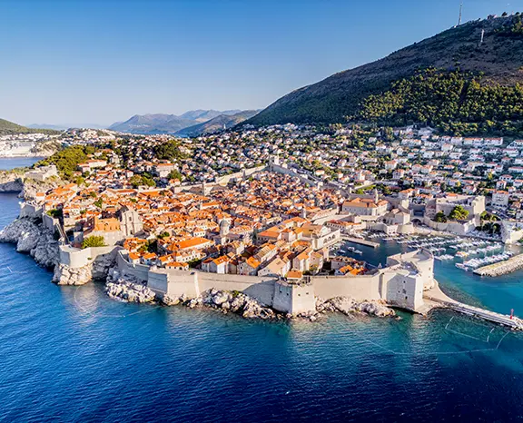
Dubrovnik
via Korčula & Hvar (14 Days).

Two weeks out of Dubrovnik, planned around shelter and wind: Mljet's lakes, Korčula, Vis and the Blue Cave, the Pakleni Islands, Lastovo and the Elaphiti.

Dubrovnik – Korčula – Hvar – Vis – Lastovo (14 Days)
Map and stops

Where each day goes

Tap a pin on the map, or a day in the leg-by-leg list further down, to open that stop with its notes and photos.

Šipan
Day 1

Dubrovnik → Šipan

A gentle first afternoon of fifteen miles from Komolac into the Elaphiti Islands. Šipan's long northwest bay gives a calm first night, and a signed footpath through olive groves leads to a Renaissance summer palace on the far side of the island.

Distance

11 NM

Sailing

~2.2h at 5 kn

This week in brief

When to sail

May to mid-October, busiest June to September

Duration

14 days · Sat – Sat

Departure

Dubrovnik

Sailing area

Dubrovnik

Leg by leg

Pick a day to go back to the map with that day's photos, notes and berthing advice.

In detail

The week, day by day

Each leg written out: where the day takes you, where to swim and eat, and where to tie up for the night.

Day 1 / 14
Šipan
1
Day 1

Dubrovnik → Šipan

Most crews leave ACI Marina Dubrovnik in Komolac late on the first day, so a short opening leg makes sense. Follow the Rijeka Dubrovačka out to sea, keep the Old Port for a daytime visit by tender rather than a night, then turn northwest along the coast for fifteen miles to Šipan. It is the biggest of the three inhabited Elaphiti islands and the one where farming still matters, with two villages at opposite ends. Suđurađ faces southeast; Šipanska Luka, on the northwest side, is larger and is where you spend the night. Its bay runs long and deep and gives good shelter, and the village quay takes boats stern-to on their own anchor, with water and power along the middle section for a modest fee. Once the lines are sorted, follow the signed path inland through the olives to Suđurađ, roughly 45 minutes on foot, where the fortified Skočibuha summer residence from the 16th century is the main sight. Back in Šipanska Luka, the few konobas cook black risotto and serve oysters brought over from Mali Ston Bay.

Things to do

Follow the olive-grove path to Suđurađ

See the fortified Skočibuha summer residence

Swim off the rocks south of the village

Try local olive oil at a small farm

Run across to Lopud by dinghy

Mooring tip

Lie stern-to on your own anchor at the Šipanska Luka quay, where the central berths have water and power. The bay is protected from the south quarter but open to northerlies, which are uncommon in summer; with more than 18 knots of north forecast, spend the night back at ACI Marina Dubrovnik.
Mljet
2
Day 2

Šipan → Polače (Mljet)

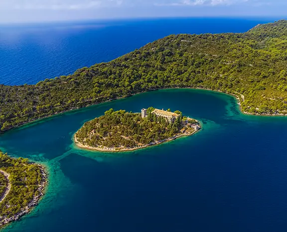
The entrance to Polače is easy to miss until you are almost inside it, which is part of why the inlet stays so calm. After twenty miles west from Šipan you slip into a long, narrow arm of water on Mljet's north coast that is protected from the north round through east to southeast, one of the best overnight refuges on the southern Croatian coast. This is one of the landings for Mljet National Park. Take a green Park buoy and pay the ranger at the kiosk on the shore, and the fee covers Park entry for everyone on board; the alternative is a stern-to place on the small village pontoon. Right by the water stand the remains of a 4th-century Roman complex, where the walls of the basilica and a corner tower are the clearest pieces. Half an hour on foot brings you to Veliko Jezero, the bigger of the two saltwater lakes, and a small Park boat crosses to the 12th-century Benedictine monastery on St. Mary's islet. If the legs are willing, the path around both lakes is about 9 km.

Things to do

Settle the Park buoy fee with the ranger

Look round the Roman basilica walls

Cross by Park boat to St. Mary's islet

Walk the 9 km circuit of both lakes

Cool off in the saltwater lakes

Mooring tip

Polače runs on paid National Park buoys, with crew Park entry included in the fee; pay the ranger when you arrive. The inlet is well protected from north through east to southeast, so it is a sound choice when the weather is unsettled.

Korčula
3
Day 3

Polače → Korčula Town

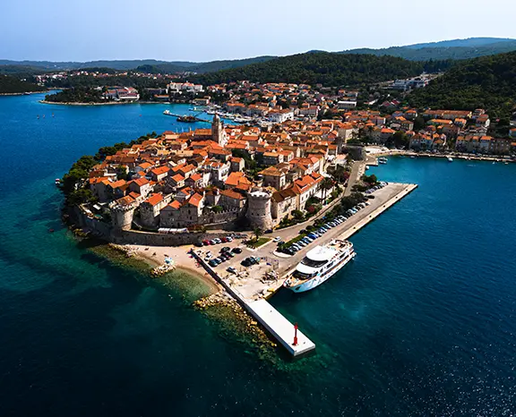
From Polače the course runs eighteen miles northwest along the Pelješac Channel, and the destination shows itself well before you arrive: a low peninsula of red roofs and a single bell tower, with the limestone walls meeting the sea on three sides. That is Korčula Town, on the eastern point of the island. Where you berth depends on the breeze. ACI Marina Korčula, on the eastern side of the peninsula, has lazy lines and full services and is the reliable choice. The town quay on the western side takes only a few boats stern-to on their own anchor and puts you right under the walls, but the westerly Maestral funnels down the channel in the afternoon and it gets rolly there. Ashore, the old town is tiny, its lanes set out in a fishbone pattern on either side of the main street. Go up the bell tower of St. Mark's Cathedral for the view over the channel, pass through the Land Gate and look in at the disputed Marco Polo House. On some evenings in season the Moreška is staged, a 16th-century sword dance in which Christian and Moorish armies do battle.

Things to do

Climb St. Mark's bell tower over the channel

Catch a Moreška sword dance in season

Stroll the walls once the day ferries go

Find the disputed Marco Polo House

Eat fish brodet in a courtyard konoba

Mooring tip

When the Maestral is up, ACI Marina Korčula on the eastern side is the place to be, with lazy lines, water and power. The western town quay is open to that afternoon westerly. Lumbarda Bay, 3 NM southeast, is the sheltered alternative if both are full.

Šćedro
4
Day 4

Korčula → Šćedro

Twenty-two miles north of Korčula, in the channel that separates it from Hvar, Šćedro gets few charter visitors. Nobody lives there and there is no village. The only things ashore are two seasonal beach restaurants on the north coast, and they lay free buoys for crews who come in for dinner. There are two bays to pick from. Lovišće on the north side is the larger, has more buoys and is the usual overnight; Mostir on the south side is smaller and quieter, with the ruins of a 14th-century Dominican monastery by the shore. Tie up in Lovišće, row ashore and choose between the two restaurants, both of which grill fish and pour local Plavac Mali. You can spend the afternoon walking across to the monastery ruins, around 40 minutes each way, or simply put on a mask off the stern. On a calm summer day the visibility reaches 25 metres, the best water of the whole trip.

Things to do

Moor on a restaurant buoy in Lovišće

Walk over to the Mostir monastery ruins

Snorkel off the stern in 25-metre visibility

Eat grilled fish with Plavac Mali ashore

Enjoy a night with no town around you

Mooring tip

Lovišće's restaurant buoys are free if you dine ashore; check on arrival. If they are all taken you can anchor on sand and weed. The bay is protected from the south; if a northerly above 15 knots is due, move round to Mostir on the south coast.

Vis
5
Day 5

Šćedro → Vis Town

Vis Town lies on the north coast of the island in St. George Bay, twenty miles west of Šćedro, and its value to a skipper is the shelter. The bay is closed to the south, southwest, west and northwest, leaving only the north, which seldom blows in summer, so it is the most dependable overnight on the island. Its long, curving promenade takes boats stern-to along most of its length, with water and power at the central berths for a modest fee. Komiža on the west side is a working fishing harbour with less room, which is why most crews come here first. History sits on the waterfront: Vis Town was the Greek and then Roman settlement of Issa, described as the earliest Greek foundation on the eastern Adriatic, and you can walk past its Hellenistic walls and the remains of the Roman baths along the harbour. A footpath leads up to Fort George, a 19th-century Austro-Hungarian fort, for the view back across the harbour. Dinner means peka octopus, white Vugava and red Plavac Mali, and the island grows a lot of wine for its size.

Things to do

Follow the Hellenistic walls by the harbour

Look at the Roman baths on the seafront

Hike up to Fort George for the view

Order octopus under the peka in advance

Taste Vugava with a village wine producer

Mooring tip

Go stern-to on your own anchor along the Vis Town promenade, with water and power at the central berths. St. George Bay is closed to every summer wind except the north, which makes it the safest bet on the island.

Komiža
6
Day 6

Vis → Komiža

Only eleven miles separate Vis Town from Komiža, one of the shorter legs of the two weeks, so there is time to stop for a swim on the way round the western end of the island. Komiža is a real working port: the fishing boats still berth on the eastern side of the harbour and there is no resort development. Head for the inner basin of the town quay and go stern-to on your own anchor; the bottom is sand and weed and generally holds well. Do not stay overnight on the outer wall, which is open to southwesterly swell. The main event in the afternoon is the climb to Mount Hum, at 587 m the highest point on Vis, by a trail that starts in town and rises through vineyards bounded by dry-stone walls and then pine forest, about an hour and a half each way. From the summit the whole archipelago is spread out below, with Italy visible on a clear day, and Tito's wartime cave is a short detour from the path. Back in the harbour, konobas serve small grilled fish with Vugava.

Things to do

Climb Mount Hum and detour to Tito's cave

See the fishing fleet in the eastern harbour

Find the Fishermen's Museum in the Venetian tower

Try grilled small fish with Vugava

Watch sunset over the open sea from the wall

Mooring tip

Berth in the inner basin of the Komiža quay, stern-to on your own anchor in sand and weed. The outer wall takes southwest swell and is no place for the night. If a southwesterly above 15 knots is coming, return the 6 NM to Vis Town.

Stari grad
7
Day 7

Komiža → Biševo – Stari Grad

Timing decides this day. The Blue Cave on Biševo is lit from an opening below the waterline, and the blue is at its strongest during the morning, so cast off from Komiža early. Tie up briefly at the small concession quay by the entrance, pay the fee at the kiosk and wait for one of the official boats that take visitors in; overnight stays are not allowed. Allow about forty minutes for the visit before setting off on the longest crossing of the fortnight, 25 miles east-northeast to Stari Grad on Hvar. Greek colonists from Paros founded the town as Pharos, and it is often called the oldest town in Croatia; the original Greek street grid can still be traced in the centre. East of the town the Stari Grad Plain, a UNESCO-listed farming landscape, has been worked continuously for a very long time. The bay is long and narrow like a fjord and protects you from every direction. Take the town quay stern-to on your own anchor or the small ACI Marina Stari Grad with lazy lines on the eastern side.

Things to do

Reach the Blue Cave boats early

Wander the Greek street grid in town

Walk out into the UNESCO Stari Grad Plain

See Tvrdalj and Hektorović's fishpond

Book peka at a konoba on the plain

Mooring tip

Both the town quay, stern-to on your own anchor with water and power in the central section, and the small ACI Marina Stari Grad with lazy lines on the eastern side are well protected. The fjord-shaped bay shelters you whatever direction the wind takes.

Palmižana
8
Day 8

Stari Grad → Hvar (Palmižana)

Expect the Maestral to be blowing as you round the western tip of Hvar, fourteen miles from Stari Grad, so plan the night before you get there. Palmižana, on Sv. Klement, the largest of the Pakleni Islands, has a small ACI marina on the east side of the islet with stern-to lazy-line berths. Space is limited, so book online for July and August or plan to anchor. The main bay holds well enough in 5 to 10 metres of sand and weed, but it rolls once the afternoon westerly comes through. The quieter nights are in the south-side coves, Vinogradišće and Tarsce, where you anchor with a line to the rocks and the holding is good in westerlies. Ashore, the Meneghello family's botanical garden, laid out in 1906, is worth a stroll, four konobas are spread round the bay, and Roman amphorae lie on the seabed off the western shore for snorkellers. Hvar Town is a short water-taxi ride east if the crew wants a night out, but sleep on the Palmižana side.

Things to do

Snorkel the amphora field off the west shore

Wander the 1906 Meneghello botanical garden

Tie a line ashore in Vinogradišće

Ride the water taxi to Hvar Town

Hike across Sv. Klement to Vlaka Bay

Mooring tip

Book ACI Marina Palmižana online for July and August. Otherwise anchor in Vinogradišće on the south side with a stern line ashore, which is better protected from the afternoon westerly. Leave the main bay if a southwesterly is building.

Vela Luka
9
Day 9

Hvar → Proizd – Vela Luka

Proizd is strictly a daytime stop, so plan your timing around lunch. The crossing from Hvar is about fifteen miles south-east to this small uninhabited islet a few miles north of Korčula's western tip. Drop anchor in 6 to 8 metres on the small sand patch on the eastern side and go ashore for the rock pools on the western side, basins cut by the waves that fill with seawater and warm up in the sun. Visibility can reach 25 metres on a calm day, and a footpath goes right round the islet in about half an hour. Proizd gives no shelter from any direction, so in the afternoon cover the last 4 miles southeast to Vela Luka. It is a deep harbour opening to the west at the far end of Korčula, with all the services of a town: fuel, and water and power along the long town quay. It stays comfortable in almost every wind, with a strong southerly the exception. The local dish is žrnovski makaruni, a hand-rolled pasta.

Things to do

Swim in the rock pools on Proizd

Walk the half-hour path round the islet

Snorkel Proizd's western shore

Taste žrnovski makaruni in Vela Luka

Take on fuel at the western end

Mooring tip

Treat Proizd as a lunch anchorage only, never for the night. In Vela Luka go stern-to on your own anchor along the town quay, with water, power and a fuel pump at the western end. The harbour is protected from north and east.

Zaklopatica
10
Day 10

Vela Luka → Lastovo (Zaklopatica)

Zaklopatica is set up for an easy arrival. The U-shaped bay on Lastovo's north coast has a low islet across its mouth that breaks the swell, and five family konobas each maintain a line of free buoys for crews who eat with them. Ring ahead, book your buoy and your table together, and the evening is planned. Getting there means nineteen miles south from Vela Luka to an island protected as a Nature Park, one of the quietest in the Adriatic in season and among the darkest places in Croatia at night. Anchoring is discouraged because of the seagrass, but outside the July peak there are usually enough buoys. On the menu are local lobster and šporki makaruli, a hearty beef-and-pasta stew. There is little to do ashore, and that is the point: on a clear August night the Milky Way stretches overhead.

Things to do

Book a buoy with your dinner table

Order lobster or šporki makaruli

Walk inland to see Lastovo's fumari chimneys

Snorkel round the islet at the entrance

Look up at the Milky Way after dark

Mooring tip

Free buoys belong to the konobas; booking dinner reserves one, so confirm when you arrive. Do not anchor in the seagrass. The bay is protected from north round to west; if a southeasterly above 15 knots is due, move south through the channel to Skrivena Luka.

Mljet
11
Day 11

Lastovo → Pomena (Mljet)

Twenty miles northeast across open water takes you back to Mljet, this time to Pomena, a small village at the western tip of the island and the other entrance to the National Park. In the bay you can take a green Park buoy, paying the ranger at the kiosk, with the fee again covering Park entry for the crew, or go stern-to on the village pontoon. Swell only reaches the entrance in a strong northwesterly. It is a quarter of an hour on foot to Malo Jezero, the smaller saltwater lake, and a short path joins it to Veliko Jezero, where the Park boat goes out to the Benedictine monastery on St. Mary's islet. Keep the afternoon free for the loop round both lakes: swimming is allowed and the cicadas are loud. The village is small, with two konobas and a tiny shop, and dinner is grilled fish with Pošip white from the Korčula vineyards across the channel.

Things to do

Take a Park buoy and pay at the kiosk

Walk a quarter-hour to Malo Jezero

Take the Park boat out to the monastery

Follow the 9 km trail around the lakes

Order Pošip with grilled fish in the village

Mooring tip

Pomena Bay has paid Park buoys that include crew entry, and the village pontoon takes a few boats stern-to on their own anchor. The bay is well protected; only a northwesterly above 18 knots sends noticeable swell into the entrance.

Saplunara
12
Day 12

Pomena → Saplunara Bay (Mljet)

Saplunara is a rarity on this coast: a bay with a sandy bottom and a real sand beach. To get there, follow the south coast of Mljet twenty miles east-southeast to the island's southeast tip, outside the National Park, so there are no Park fees. The bay is wide and shallow, with pale sand at 4 to 6 metres, ideal for anchoring, and the two beach konobas also lay seasonal buoys. It is protected from north, northwest and west; only a southerly sends swell into the inner part. With a sandy bottom and shallow depths, the water turns a deep turquoise and swimming off the boat is excellent. For a walk, take the path twenty minutes north to Blace, a smaller and quieter sandy beach, or climb to the little white chapel above the village. There is not much to Saplunara itself, a few stone houses and the two konobas on the sand.

Things to do

Anchor on sand and swim off the stern

Walk twenty minutes to Blace beach

Climb up to the white chapel

Try grilled orada at a beach konoba

Watch the stars from the deck

Mooring tip

Anchor in 4 to 6 metres on sand, where holding is excellent; restaurant buoys are free if you dine ashore. The bay is open to the south. If a southerly above 18 knots is forecast, go 6 NM north to Okuklje, which is also outside the Park and well protected.

Lopud
13
Day 13

Saplunara → Lopud

Lopud is the right place for the penultimate night because the base is so close: the morning run is short, so you can relax on the last full day. The crossing from Saplunara is ten miles east to the second-largest of the inhabited Elaphiti islands. There are no cars on Lopud. The village curves around the main bay on the northwest side, and its quay takes boats stern-to on their own anchor, with water and power at the central berths for a modest harbour fee. The bay is protected from the south quarter and open to the north, which is uncommon in summer. A thirty-minute walk across the island leads to Šunj on the southeast coast, one of the few natural sandy beaches in Croatia and the main reason people come. On the waterfront in the village is a fortified 15th-century Franciscan monastery, and a ruined fortress above the houses gives the wide view. Dinner is black risotto or oysters from Mali Ston Bay.

Things to do

Walk across the island to Šunj beach

See the fortified Franciscan monastery

Climb to the ruined fortress above the village

Order Mali Ston oysters on the quay

Share a black risotto at a konoba

Mooring tip

Lie stern-to on your own anchor at the Lopud quay, with water and power at the centre. With more than 18 knots of north forecast, move 4 NM to Šipanska Luka on Šipan, which is better protected, or go straight to ACI Marina Dubrovnik.

Dubrovnik
14
Day 14

Lopud → Dubrovnik

Check-out is in the morning, so the last eight miles start early. Pass Koločep, the smallest of the inhabited Elaphiti islands and the closest to the city, and stop in one of the small bays on its eastern side for a final swim, anchoring on sand in 6 to 8 metres. Then turn up the Rijeka Dubrovačka to the pontoon at ACI Marina Dubrovnik in Komolac. Before inspection the yacht needs fuel, empty holding tanks, rinsed decks and a checked inventory, and the skipper should stay on board while the base team goes through it. Your charter contract gives the exact times. The marina is a few kilometres up the inlet from the Old City; bus 1A or a taxi gets you to the Pile Gate in about a quarter of an hour. Walk the city walls, then have a long lunch in the lanes behind Prijeko, a good way to end one of the longest round trips on the Croatian coast.

Things to do

Have a final swim in a Koločep bay

Refuel and pump out before inspection

Walk the full circuit of the city walls

See the Rector's Palace or the Franciscan cloister

Linger over lunch off Prijeko

Mooring tip

Come into ACI Marina Dubrovnik and take the berth the base staff give you. Check your contract to see whether you must be back the evening before or by the morning, and allow about half an hour from the pontoon to the Pile Gate.

— Plan your week

Book this week and we'll find the boat for it.

Tell us your dates, how many of you are sailing and the kind of boat you like. A charter agent sends a quote for this route within hours.